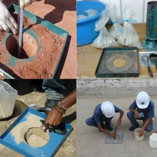
The sand cone apparatus is a practical field device that travels with our crews to every compacted lift in Milwaukee. It consists of a graduated plastic cylinder, a precision metal cone with a valve, and calibrated Ottawa sand that flows freely into a test hole. When verification matters for a subgrade along the Menomonee Valley or structural backfill behind a new retaining wall on the East Side, this method delivers a direct measure of in-place wet density without relying on nuclear gauge correlations. ASTM D1556 governs the procedure from hole excavation through sand volume determination, and our lab maintains ISO 17025 accreditation for the balance and calibration checks that support every test.
Milwaukee's compacted fills often sit over compressible lacustrine silts that deposited when glacial Lake Michigan covered the area roughly 12,000 years ago, making lift-by-lift compaction control a non-negotiable step before plate load testing confirms bearing response. We run the sand cone in granular backfill, crushed stone base course, and engineered clay liners where a nuclear gauge reading would need site-specific correction curves that the Wisconsin geology makes unreliable.
A sand cone test gives you one number that nobody disputes: the pounds per cubic foot actually compacted into that lift.
Our approach and scope
Soil behavior shifts noticeably between the weathered till mantling the Kettle Moraine uplands west of the city and the deep organic silts that underlie the harbor district near Jones Island. In the uplands, dense sandy till with gravel lenses compacts to 95 percent of modified Proctor maximum with moderate effort, and a sand cone test checks that the top 12 inches of subgrade actually hit that target before a
CBR road test determines pavement section design. Down near the inner harbor, the same compaction specification on a clayey silt fill requires tighter moisture control because the natural water table sits barely 4 to 6 feet below grade, and the sand cone becomes a verification tool on every lift of engineered fill placed above the dewatered clay.
Contractors working on brownfield redevelopment parcels in the Menomonee Valley often encounter heterogeneous fill with brick fragments and cinders from the city's industrial era, and the sand cone hole excavation reveals whether that material is consolidating uniformly under the roller pattern. When the specification demands 98 percent relative compaction beneath a
mat foundation, we correlate the sand cone density with laboratory Proctor values from the same borrow source to confirm that the fill will not settle differentially once the structure loads are applied.
Quick answers
How much does a sand cone density test cost on a Milwaukee project?
A single sand cone test with calibrated Ottawa sand, field moisture content by Speedy or oven-dry, and a signed report typically runs between US$100 and US$140 per test location. Mobilization to the site is quoted separately based on distance and the number of tests scheduled in a single day. Volume pricing applies when we are on site for a full shift of continuous compaction testing.
What soil conditions make the sand cone method unusable?
The sand cone method works poorly in soils with coarse gravel or cobbles larger than about 2 inches because the test hole walls collapse and the sand cannot fill the void accurately around the large particles. It is also not recommended for very soft, saturated cohesive soils where the excavation itself remolds the material and changes the in-place density. In those conditions we typically switch to a drive-cylinder method or, for granular soils, a water replacement technique.
How does the sand cone compare to a nuclear density gauge for Milwaukee clay fills?
The sand cone gives a direct measurement of excavated soil mass and hole volume, so there is no calibration curve between gamma radiation count and density that needs adjustment for Milwaukee's glacial clay mineralogy. Nuclear gauges require site-specific correction factors because the hydrogen content in the clay lattice affects the neutron moderation reading, and those correction factors drift seasonally as the clay moisture profile changes. For critical compacted clay liners and structural fill, the sand cone is the referee method.
How many sand cone tests does Milwaukee code require for a commercial building pad?
IBC Chapter 18 does not prescribe a universal number; it requires that the geotechnical engineer's report establish the frequency. For a typical commercial building pad in Milwaukee, we commonly specify one density test per 1,500 to 2,500 square feet of each compacted lift, with additional tests at utility trench crossings and around foundation excavations. The city plan reviewer will check that the testing frequency in the special inspection statement matches the project geotechnical report.